| Texas and New Mexico (8 Areas) |
Back to Pictures (Texas) Back to Pictures (New Mexico)
Guadalupe Mountains National Park - Texas (Summit Hike & Devil's Hall) Big Bend National Park - Texas McKitrick Ridge – Guadalupe Mountain National Park, Texas Triassic Trail (Table Rock) - Palo Duro Canyon State Park, TX Upper Canyon Trail – Caprock Canyon State Park, TX Austin and San Antonio, TX (Enchanted Rock, Perdenales Falls, Hill Country & Colorado Bend) Alkali Flat Trail - White Sands National Monument, New Mexico Dining Tips: we love to hit the local eateries/diners, for example, near Colorado Bend, there is no potable water & food within 20-30 miles from the park; we encourage you to experience Southern Texas hospitality at Lometa's local diner. Drop by and say hi to the sisters that runs the diner. Visit the local establishments and stay away from Chains to keep our towns vibrant.
Guadalupe Mountains National Park - Texas (Summit Hike & Devil's Hall) Get to the trailhead was easy; the trailhead parking lot sits next to the Pine Springs Campground. Just drive straight until the road dead-ends. We got there around 9:00am and started the ascent. What surprised us the most was the ruggedness of the trail. Hiking boots with stiff soles are highly recommended since the trail is mostly litters with small to medium size rocks. This translates to a lot of pounding on your feet. If you have time to stop and linger, you will probably discover fossils. We encountered quite a few rocks with fossilized shells. The beginning of the climbs followed the side of Pine Spring Canyon, then circled to the back of the mountain, up through a pine forest, and onto the final push to reach the summit. The summit offered a spectacular view of the Salt Flats, Chihuahua Desert, etc. During the last section of the trail, the sun reflected off the quartz crystals and I told Mary we were walking on diamonds. On the summit, the greater than 270 view will beg you to take tons of pictures. Since we love heights, we sat on a boulder outcrop with a steep cliff below us. We felt as if we were suspended in mid-air. In hindsight it was pretty dangerous since this mountain is not for climbing and the rocks easily crumbles. Before descent, we made our way to the obelisk that marks the summit. We opened the metal box and signed the register. I noted someone left an emergency blanket up here – something to remember if you didn’t bring enough cloth and find it’s too late to descent. By the time we reached the parking lot, it was around 5pm - we took lots of breaks and pictures. The hike can be done in 5-6 hrs with a steady pace. Tips: visit when it’s cool (we visited in November) and bring lightweight layers/hard shell for extreme temperature fluctuations; bring enough water. No need to bring a GPS - one way in, one way out. Start early or bring powerful flashlights. Side Trips: 1) Sharing the same trailhead is the Devil's Hall hike; this narrow 4 mile (round trip) gorge hikes is fairly level but the trail is rocky toward the end. There are some gorgeous maples and rugged canyon scenary. 2) Not far from the visitors's center you will find the Smith Spring's loop trail. The trail offers a relaxing stroll (albeit some elevation gain) to introduce you to the landscape of the region.
Big Bend National Park & Surrounding Areas We spend the 1st couple of days in the outer skirts of the Big Bend mountains. Spending the night in the Ghost town of Terlingua was a memorable experience. Unlike other Ghost Towns we’ve visited before, there is a small thriving community that lives in Terlingua permanently. There are rustic but decent lodging/BBs along with a fully operational saloon/restaurant. Listen to country music while dining on semi-authentic Mexican cuisine was a good experience. The best part of the stay is to wander around the decaying buildings and ruins, an excellent place to take HDR photos. No trip to Big Bend should be without a visit to Terlingua. Other places surrounding the Big Bend Mountains that are worth mentioning include the Sana Elena Canyon Trail (for a spectacular view of the Rio Grande and Canyons) and the Grapevine Hill Trail (a.k.a. Balanced Rock). When we spent the nights in the mountains, we were most rewarded with the hike up the Lost Mine Trails, the scenery may not be in the same league as a Colorado peak but the views and the gale force winds were enough to etch into our memory. Note: the most famous hike in the area is the South Rim trail. Distance: Grapevine & Santa Elena (~2 miles each), Lost Mine (~5 miles), roundtrip
McKitrick Ridge – Guadalupe Mountain National Park, Texas McKitrick Ridge starts off at the McKitrick Canyon Trail. On the date of the hike, we had no intention to reach the ridge top and only decided to reach the Hunter’s Cabin off a leveled hike through the canyon floor. Along the way we visited the Pratt’s Cabin and the Grotto. Honestly, since we didn’t visit in Fall and missed the fantastic show of red and yellow, we didn’t see a whole lot on the canyon floor and decided to press on beyond Hunter’s cabin… this turned out to be a fantastic surprise. There were moments of déjàvo when we climbed… at the canyon floor, I pointed to a Hoodoo like rock WAY UP on the top of the mountain and joked with Mary that we will get there… honestly my gut feeling is that we will turn around long before reaching that point. But guess what? In about an hour, we were standing above that Hoodoo and walking on the ridgeline on the other side of the mountain… (Remember the “Analogy” I wrote in “Contact Us” section of the webpage?) The climax of the hike has to be the ‘notch’ where we crossed the spine of the ridge and is able to look east at the North McKittrick Canyon and south into the South McKittrick Canyon. When I first peered through the notch I was awed by the sight of another valley; the giant slab of rock in front us felt so close that we can almost touch it. The rock had a straight, brownish, almost Chinese watercolor-like façade with a hint of menacing vibe… “I don’t think this mountain welcomes climbers (with ropes & all)”, I joked with Mary. We continued about half a mile on the ridge top and turned around when we approached our pre-establish turnaround time (1:00pm). We stopped short of the reaching the campground by a few hundred feet. Tips: Carry enough water, wear sturdy hard sole boots. Watch for trailhead closing hours and establish a turnaround time. Distance: ~ 10+ miles roundtrip
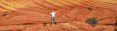
Triassic Trail (Table Rock) - Palo Duro Canyon State Park, TX Palo Duro (and Caprock Canyon) offers some unique scenery for this part of the country – the landscape resembles that of Utah and Arizona. The vistas are not as expansive as Canyonland but who says Texas is flat! Palo Duro is only about 25 miles South of Amarillo. This makes the park a fairly popular destination for the folks living around the area. Get to the park, from Amarillo, take I-27 south. Exit State Hwy. 217 (exit #106) and turn left (east). This will take you directly to park entrance. Triassic Trail is the only route that begins at rim level (at the visitor center). Stop at the visitors’ center to obtain a map of the trail or follow the signs at the visitors’ parking lot. The start of the trail involves a gradual climb next to the cliffs (to our right). About two third ways up the trail, we noticed the amphitheater dwarfed under us (on our left). The trail gradually levels off and we found ourselves traveling on the edge of a plateau, the plateau then gave away to a narrow ridge that ends in a rocky summit (a.k.a. Table Rock). From here, we backtracked and returned to the parking lot. We chose this trail because it took us to one of the highest point in the park. Note: on your way down, there should be a side trail leading you down to the amphitheater. This trail seems to be very steep and you must find a way back to your car (hitch a ride or walk). Ask the ranger about the entrance/exit by the amphitheater… if conditions allows, you can save yourself a couple miles of gradual climbs by enter near the amphitheater. Tips: no special equipment is needed for this hike. Distance: ~ 7 miles roundtrip Rating: 8 out of 10
Upper Canyon Trail – Caprock Canyon State Park, TX Upper Canyon Trail (and the Triassic Trail in the nearby Palo Duro) is perhaps the best two hiking trails in Northern Texas, and one of the best Texas State Park hikes, IMO. One of the best part is that these trails is their location, they are within driving distance from many nearly cities, including Dallas/Fort Worth. Getting there: The State Park is located in the middle of nowhere, we stayed at Hotel Turkey in the town Turkey the night before. Based on the town newspaper, the hotel was to be donated to charity a month later. We felt fortunate to have stayed in a piece of history. Camping is probably a better choice for this park. We arrived at the park and visited the only ranger stationed at the park. She told us about the loop hike. From the park entrance we drove north on the park's main road, past the tent camping area and arrived at the trailhead. I believe it’s the North Prong parking lot. The 1st section of the hike was an easy stroll on a well maintained dirt trail. For now, the trail skirts the perimeter of the ridge and we headed toward denser vegetation, the trails narrows and follow a creek bed periodically. In the distance, we could see a few hoodoos; another nice surprise in this part of the country. The second section of the hike starts when the trail abruptly turns left and we started a steep climb toward the ridge top. The steep hike took us to the Fern Cave; it’s not much a cave looking from the outside other than a hole in the wall with lots of fern. I was not impressed but the cool breeze emanating from the ‘cave’ was a nice relief from the heat (and this was in January). By the time we got the ridge top, the temperature is cooler again with wind gusts swept over the ridge top. There are overlooks on both sides of the ridge but we didn’t linger for too long due to the wind gusts. As we skirted around the ridge top, we started to make our way down… the wind actually picked up and Mary was ‘blown up’ like a balloon by the gale force wind. The highlight of the trail is the Haynes Ridge Overlook. There is a weather beaten chair and a sign next to the overlook. I remember the view extends to the horizon at this point. From here we also saw our car. We followed a trail headed down toward the parking lot. This trail was extremely rocky and rugged. It’s more like a water runoff than an actual trail. But this was the shortest distance to our car. Overall this was good hike. Don’t quit when you have made it to the cave, the best part is yet to come. Tips: very windy on the ridge top, use the modified via-ferreta setup on your kids if you are afraid to have them blown away near the overlooks. See our Tips section. Distance: ~ 6.5 miles roundtrip Rating: 8 out of 10
Austin & San Antonio Enchanted Rock – located near Fredericksburg, this place makes a great weekend trip. This 400 feet rock is literally a piece of giant rock. It’s hard to describe and you’ll have to experience it yourself. We took a short stroll to the ‘rock top’ but will probably be back for some bouldering and hiking around the rock. The place was packed and the line of cars extended all the way to the highway. Perdenales Falls State Park – located near Johnson City, this place boasts some of the clearest water in Texas I have ever seen. We went down to the riverbed and scrambled up and down the river. There are lots of nooks and cranny to explore. Be warned, talk to the ranger prior to entering the river and ask about flash flood danger. Colorado Bend State Park - located near Bend, TX. This remote location is designated as a primitive area with a long 8 mile country road to the park's center, if it wasn't for the frequent stump on the brakes when faced with upcoming trucks; I almost thought we were in a New England Rally Race... A word of caution, please drive slow and show courtesy to your fellow travelers (less rocks and dust for everyone to swallow). This place is suppose to offer good fishing when White Bass is spawning. For hiking, there is a nice waterfall hike and a surprisingly tranquil creekside trail. Talk to the rangers to learn about trail conditions since recent rainfalls may cause some trails difficult to pass. Hill Country State Natural Area – located near Bandera, this place is a showcase for the “hill” known to outsiders as the Texas Hill Country. We parked at the “Trailhead Equestrian Camp Area” and took a giant loop trail extended all the way the Wilderness Camp Area. The scenery is ‘mild’ to our taste but it’s definitely worth a trip if you are not going to the Canadian Rockies anytime soon. Side Trip: San Antonio Missions Nat'l Historic Park - the park consists of a number of missions and provides spectacular photo opportunity.
Alkali Flat Trail - White Sands National Monument, New Mexico The Alkali Flat Trail is the longest trail at the White Sands National Monument (about 90 miles North of El Paso, Texas). On the date of the arrival, we were tired from the long hike at Guadalupe the day before so we decided to take a stroll around the dunes instead. Before we know it, once we realized we carried enough water, the stroll turned out to be a ~5 mile loop hike. To minimize the afternoon sun, we hiked in a counterclockwise fashion (toward the right). The hike was not very strenuous. There were some elevation changes but it’s no more than traversing the small sand dunes that stretches miles all around. The trail marker indicated Alkali Flat Trail when we reached the half way mark – this flat area is suppose to be the origin of these sand dunes and a lake during the last ice age. Despite the well erected orange trail markers, it’s still a good idea to mark your car’s location as a backup. You can also use the distant mountains and the sun as a general indicator of your location. This is another one of those trails that exceeded our expectation. We didn’t think the gypsum white sand can offer such fantastic display of wilderness and beauty punctuated with pockets of vegetations, ‘hoodoos’, and absolute tranquility. We hiked before sundown and met only few people along the way. Our minds were totally blank and all worries were carried away by the sand drifts. Picture opportunity in this place is out of this world and is only limited by your imagination. Tips: For your safety, register at the trailhead. Bring enough water, wear gaiters and try to cover yourself up (head to toe). Note we covered our entire face with bandanas; this helped us to retain moisture. Carry LED lights for late afternoon/early evening hikes. We also chose winter to hike this trail. If this had been in summer, I can’t image anyone getting out their car let alone walking. Distance: ~ 5 miles roundtrip
Wheeler's Peak - near Taos, New Mexico The recommended trail is from the Wheeler Summit trailhead. It’s longer at ~13-14 miles but offers a more gradual ascent and a longer walk above the tree line. We opted to take the shorter ~8-9mile hike via the Tao Ski Area. Trailhead is at (N36 35.8192 W105 26.9369) on the right side of the dirt road past the official Tao Ski area asphalt parking lot, but you can also park at the end of the dirt road to save yourself a quarter of a mile. If lost, look for signs to William’s Lake next to the ski lifts and the Lodge Restaurant/Pub. The drive from downtown Taos was uneventful but the last bits of dirt road could pose problems for 2WD sedans if the weather turns. This was one of the toughest hikes we’ve tackled. Due to unfavorable weather forecast, we had no choice but to hike the trail 1st thing in the morning after arriving from Dallas the night before. Having just 12 hrs to raise red blood cell counts was not happening… the trails climbs at a rate of ~700 feet/mile at certain sections. The hike can be broken down into 3 major sections. The 1st section was a gradual, pleasant stroll through the pine/aspen forest, this 2 mile can be taken at a leisurely pace to Williams Lake. It’s impossible to get lost, signs were clear and easy to follow. Right before arriving at Williams Lake was a sign post with Williams Peak pointed toward the left. On the day we hiked, I actually hesitated at the trailhead until we talked with a couple looked to be in their 80’s; they told us they were going to the summit the 2nd time this week. If they can do, we can do it! It wasn’t later when we met them on our way down they told us they had a week to acclimate. When she asked where are we coming from, we told the ‘young’ lady that we arrived last night from Dallas, she said “Holly S***”! That a girl. :) The 2nd section is the switchbacks and the start of the abrupt ascent from the Williams lake/Williams peak sign post. This is when the rate of my ascent crawled to ~1 mile per hr per my estimate. I can feel my heart beating feverishly at the end of every few hundred yards, and I had to take frequent breaks. This only got progressively worse as we got up higher. The 3rd section was the switchback above the tree line followed by a short push along the ridgeline to the summit. The most memorable section of this section was the wind! The wind was so strong that it forced some of the unprepared hikers to abandom their summit bids right below the ridgeline. When we arrive at the saddle, we took the trail on the other side of the saddle (away from William’s lake) and avoided the wind whip on the ridgeline… this resulted in overshooting the summit a little bit but it was all fun. At the summit there is excellent view across the mountain ridge where you can follow your sight along the ridgeline in both directions to other summits I cannot name. The trails also extend in both directions to allow further exploration. The summit is relatively tame/flat when compared to some of the Colorado peaks but still offers a sense of gratification. Distance: ~9 miles roundtrip Site Trips (Northern New Mexico & Colorado Boarder) 1) The badlands is a vast network of geographic phenomena across the Northwestern New Mexico. In total there are 9 areas. The area is extremely rugged with no services, and the rock formations are extremely fragile. If interested in learning more about the area, please email us for directions & recommendations. You can find more pictures of the Badland in our photo community website (follow the link on the home page). 2) Bandelier National Monument is worth a visit during cooler months of the year. This educational trip takes you to the cliff dwellings of the ancient Pueblo people. The highlight of the hike is a 4-5 story high ladder climb onto a cliff dwelling (Alcove House) perched on the top of a cliff. 3) Situated in the middle of the Badlands of New Mexico is Chaco Canyon National Park. It's a highly coveted destination for photographers. However, you need to be ready for a filling loosening ride on a washboard dirt road ~16 miles long. 3) Great Sand Dunes National Park is in Colorado but it's just a short drive away from Taos not far from the CO/NM boarder. The dunes are much taller than the ones you will find in White Sands but the color of the sand is less interesting. Nevertheless this is a popular photography destination worth a visit.
|